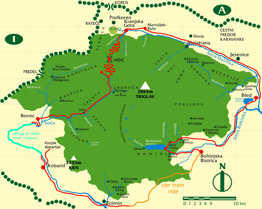
Triglav National Park - Kort
Where can I spend the night?
How can I get to the Park by public transport?
Is canyoning in the Park allowed?
Is camping in the park allowed?
How to climb Triglav?
How to plan a safe mountain tour?
Can the “P” marked car parks in the TNP be used for caravanning, and is overnight parking allowed?
Is bathing in high-altitude lakes allowed?
Who are park rangers?
What are the most important rules to be followed by mushroomers?
Are we allowed to pick herbs in the Park?
What’s the weather forecast?
Does TNP also organize guided tours of the Park?
Where can I spend the night?
Accommodation facilities are available in the mountain huts belonging to the Triglav National Park Public Institution, in theTrenta Lodge and alpine huts and bivouacs. The list of mountain huts in Triglav National Park, as well as their opening times and telephone numbers, can be found at the website of the Alpine Association of Slovenia (AAS): http://en.pzs.si/koce.php?reg=3The AAS recommends visitors to bring their own bed linen.
Accommodation is also available in some camping sites, hotels, guest houses, private rooms and holiday flats.
The list of tourist offices:
http://www.bled.si
http://www.bohinj.si
http://www.bovec.si
http://www.kranjska-gora.si
http://www.lto-sotocje.si
Top
How can I get to the Park by public transport?
For more information on bus and train routes, click here .
Top
Does TNP also organize guided tours of the Park?
Guided tours are listed in the annual calendar of events and published on TNP’s website. TNP-guided tours, which vary from easy valley walks to more demanding high-altitude tours, are also available on request.
Information: triglavski-narodni-park@tnp.gov.si
Top
Is camping in the park allowed?
Camping outside specially designated areas is not allowed. Camping designated areas are official camping sites and several camping locations used mainly by scouts and mountaineers, e.g. in Ribčev laz in Bohinj (Gosti les and near the Bellevue Hotel), at Rudno polje on the Pokljuka plateau (by the military cable-way), in Martuljek, Krnica pod Vršičem and in the Loška Koritnica Valley.
Top
How to climb Triglav?
There are three important ascent routes to Triglav. The Bohinj Alpine Path, dedicated to the Bohinj mountaineers who were the first to ascend Triglav in 1778, the approach from the Upper Sava Valley (Mojstrana) dedicated to the renowned Triglav priest Jakob Aljaž, and the Trenta Route inspired by Dr Julius Kugy. Those wishing to explore the kingdom of Triglav in detail will have to take all three, and their many variants. But for a chance visitor to the Julian Alps and Triglav, each and every one of these routes will quench the thirst for mountaineering experience and beauty. The focal points in the description of these routes are the huts of the Triglav National Park. Consequently, the ascent from the hut to the top of the mountain is described first, followed by an explanation of the lower sections of the route.
The Planika Route or the “First Men on Triglav” Route
Although this is believed to be the easiest of approaches to Triglav, it should not be underestimated. From the wide depression behind Dom Planika the path slants up across crumbly ground as far as the steep saddle Triglavska Vrata and further up the secured route to the top of Mali Triglav, where it joins the climbing route from Kredarica. From there, it is an airy climb along the ridge to the top of Triglav (1.45 h).
Dom Planika, the starting point of this Triglav ascent, is reached after an easy, two-hour panoramic walk from the mountain hut Vodnikov dom on Velo polje, which is the oldest of all the described approaches.
The path to Velo polje used to be a “compulsory” shepherd's path from Stara Fužina in Bohinj through a side valley and over the Voje valley. Because of this path, Voje has come to be called “the green door to Triglav”.
From the end of the valley, near the Mostnica waterfall, the path sets off to Velo polje across Spodnja Grintojca, steeply to Zagon and then gently to Vodnikov dom (4 hours from Stara Fužina to Vodnikov dom).
At Zagon the path is joined by currently the most frequented route to Velo polje, which starts at Rudno polje on the Pokljuka plateau.
The most popular, yet quite demanding, climbing route to Triglav runs from the mountain hut Triglavski dom na Kredarici. The route is dedicated to the memory of the Triglav priest, Jakob Aljaž.
Climbers are assisted by a secured rope throughout the climb because of the gaping precipices stretching all the way to Mali Triglav. From Mali Triglav the route winds up along the ridge to the top, as described in the Planika Route (1.15 h).
To reach Triglavski dom na Kredarici, mountaineers normally start from the valleys Vrata, Kot (past Staničev dom) or Krma.
Through Krma the inhabitants of Zgornja Radovna (the Psnak family, in recent time) have been supplying the mountain huts Triglavski dom and Staničev dom. Being gentle and reasonably safe, apart from snow avalanches, the path is favoured by ski mountaineers in winter and spring.
Secluded but breath-takingly beautiful is the path through the Kot valley, which runs across a sunny, panoramic Lengar pasture, below the rock faces of Rjavina and Vrbanova špica to the mountain hut Staničev dom and then on to Kredarica.
If you are looking for a more frequented path, choose the one from the Vrata Valley. The lively Triglavska Bistrica, roaring Peričnik Waterfall, dense forests stretching to the first outcrops and the mighty Triglav North Face will indeed make your heart beat faster. It is a waste to drive through that section of the road. Instead, take the Triglavska Bistrica Trail and shorten your walk significantly (12 km, approx. 2.30 h).
Aljažev dom (accommodation), a popular starting point for mountaineering trips in Vrata, offers three ascents to Triglav, none of them easy.
The Prag Route, which is the most popular of all three, climbs the first rock step at the end of the valley (roped section). Then the path follows a long grassy ledge at the edge of the Face and rises gently towards the saddle between Triglav and Cmir on the one side and Begunjski vrh on the other. In the second third of the route you must climb an over-10-metre-high, vertical step, which is secured with a rope. Once you have climbed it, the path eats up into the tiring screes below Triglavski podi. The Face is now forced to leave the climber’s scene, only to be replaced by a view of the top reaches of Triglav. The terrain flattens out on a karst plateau and then rises, one last time, to Triglavski dom (from Aljažev dom in Vrata over Prag to Kredarica 5.15h).
The routes from Vrata are not suitable for everyone as they require some climbing experience, stamina and climbing equipment. Use of a helmet and an alpine axe is compulsory.
From Dolič in the footsteps of Dr. Julius Kugy
From the mountain hut on the Dolič saddle follow the serpentine bends of the old mulattiera to the ruins of a former Italian barracks Morbegne (refuge) and up the scree slopes to Triglavska škrbina. A secured path takes you to a red gully just below Škrbina (Notch) and then zig-zags across the steep southern slopes of Triglav, finally climbing up the south-western ridge to the top (2.30 h).
The roads to Dolič run from Trenta, Velo polje, Triglav Lakes via Hribarice, and along the Mira Marko Debelak’s climbing route behind Kanjavec. The most frequented path to Dolič is the one along the Triglav Traverse (Triglavska magistrala) from the Triglav Lakes Valley via the Hribarice pass. As this path is well-known and described in detail in other publications, we will set on our way to Dolič from the TNP Information Centre Dom Trenta at Na Logu in Trenta.
Follow the road to Vršič. At the first serpentine, take the gravel road into the valley Zadnjica (by car to the car park). At the car park, a path branches off left for Kriški podi, but we continue past a road barrier at the end of the valley, considered among the most beautiful in the Julian Alps. The valley is surrounded from all sides by precipitous cliffs so it is cold in the winter and filled with pleasant coolness of a mountain refuge during summer. Former pasturelands, scattered with boulders and sheep sheds, are governed by the towering rock faces of Kanjavec and Vršac. At the foot of these rock faces, there is a junction of mountain paths. To the left, a path runs to the steep Zadnjiški Dol and to the old alp Trebiščina and the Prehodavci pass, and to the left a mulattiera takes the mountaineer to the Luknja pass and the Dolič saddle. The path running straight is a less popular climbing route over Komar directly to Dolič. The mulattiera offers a more pleasant, but much longer walk. A good hour above the end of the valley our path forks right, descends slightly and then winds up towards Jalovec and Dolič. Just a few steps below the mountain hut, the mulattiera branches off towards Triglav (4 hours from Na Logu).
Top
How to plan a safe mountain tour?
The number of mountaineers has been increasing, partly due to the fact that the hiking season now lasts almost all the year.
The following instructions are intended for visitors who do not know the Julian Alps well, and to those who have little or no mountaineering experience.
The Triglav National Park covers almost entire area of the Julian Alps within the borders of Slovenia. This world of high mountains is governed by conditions which differ (sometimes greatly) from the conditions in the valley. Conquering high mountains requires good physical conditions and, above all, skill, neither of which can be acquired overnight.
The mountains are also full of life forms adapted to the harsh conditions of the mountain world. As life in the mountains is often on the verge of existence, each visitor should try to minimize his/her impact on this sensitive environment.
We wish you many exciting mountain tours and a wealth of unforgettable memories.
Selecting a mountain tour with regard to the time of year:
Summer – long, warm and even hot days with sudden weather changes. Sudden cold fronts bring storms (wind, rain, lightning, considerable temperature drops). In high mountains, snow patches that a mountaineer needs to know how to overcome stay far into summer, the risk of falling stones is high, caused by visitors, wind, or animals.
Planning a tour:
adapt the length and difficulty of the to your state of fitness, health status, experience, knowledge of the mountains, available equipment, and the weather forecast (easier tours first)
weather forecast for the mountains is available on the Internet, radio, TV
when you are not familiar with the area of the planned tour, consult an expert or hire a mountain guide
prior to departure, leave a note in a visible place stating your destination, anticipated time of return, and the names of all the people venturing on the tour
Equipment:
proper footwear (high mountaineering boots with sharp rubber soles)
warm clothing (jumper, cap, gloves, spare underwear)
wind and rain protection (rainproof anorak or windjacket, windproof trousers, bivouac bag, emergency foil blanket)
sun protection (sun glasses, a hat or cap)
a first-aid kit (band-aids, gauze, bandages)
orientation equipment and the skill to use it (map, altitude meter, compass)
suitable food and drinks supply
and for winter tours: ice-axe, crampons, avalanche rescue beacon, snow shovel, avalanche probe.
for easier and safer walking (folding) poles and an ice-axe are recommended at all times when snow and ice can be expected.
Top
Can the “P” marked car parks in the TNP be used for caravanning, and is overnight parking allowed?
The Triglav National Park Act prohibits the parking of motor vehicles, campers, and caravans outside the designated areas (Article 13, point 43, of the TNP Act - Official Gazette of RS, št. 52/10).
In the area of the Park there are no car parks which would be also intended for camper parking, overnight parking or supply. Only camping sites currently serve as regulated area within the Park that can be used by campers.
Only the Bovec Municipality has adopted a Decree on the traffic regime for campers and the parking regime applicable to camper parking sites.
Top
Is bathing in high-altitude lakes allowed?
Bathing and swimming, as well as all other recreational activities, are banned at alpine lakes which fall under the first protective regime (Article 15, point 17, of the TNP Act, Official Gazette of RS, no. 52/10).
Route: Kranjska Gora, Jesenice, Slovenien --> Mojstrana (Triglav Museum(Maps available) --> Triglav National Park
It costs a couple of Euros to park at the trailhead, where you will begin your ascent no matter which of the two advertised routes you take.
After passing a giant carabiner monument to World War II veterans, the trail follows a gurgling stream whose water is so incredibly clear that you almost can't even see it. Soon, you will come to a place where the two main trails diverge -- one goes straight on up the valley and the other crosses the creek to the left and heads straight into some cliff faces. Ironically, this is the trail you want to take. It's marked by a large red bulls-eye to mark the start of the trail and almost immediately up the Prag route you begin to run into the via ferrata, or iron rungs, posts and chains bolted to the rock, that enable you to get past some of the most dangerous sections.
We, however, continued straight up the valley on the Luknya, or Bamberg, route which takes you to a tiny saddle on the shoulder of Triglav's far north face and to a point where you don't want to be if you are the least bit afraid of heights. The next hour is spent clawing and scrambling your way straight up several vertical cliff faces using only the via ferrata embedded in the rock. The exposure is dizzying, with fatal drops of several thousand feet directly below you.
Even the standard route isn't easy. You climb through many sections that would be impassable without the aid of the rungs and chains. And that's before you reach the Triglavski Dom hut at 8,251 feet in a saddle on the ridgeline leading to the summit. From here, there is still an hour of solid climbing ahead of you, all of it right up the spine of the ridge, over the summit of Mali Triglav, or "little" Triglav, with most climbers using via ferrata gear -- a harness and clips -- to attach themselves to the cable that runs up the middle of the ridgeline virtually all the way to the summit.
Once on the summit, you are greeted by the Aljavez Stolp, a conical-shaped building that sits atop Triglav. The structure was built in 1895 in honor of Jakob Aljazu, a local priest considered the father of Slovenian alpineering. On this day, with clouds having socked in the mountain the entire day, the only views are actually inside the Aljavez Stolp. Someone has painted a 360-degree panoramic mural of the surrounding mountains on the inside of the building, and on clear days one can see all the way to Grossglockner, the highest point in Austria.
To get down off Triglav can be even harder than climbing it. Returning by the standard route is still a tedious and painstaking process, as you must descend back down the ridgeline to the Triglavski Dom over a narrow rib of rock that sports precarious dropoffs on either side. Many have fallen to their death here. Many climbers on this day weren't taking any chances and had the proper via ferrata gear.
The roundtrip can be easily done by any fit climber as a day trip -- we took only seven hours to do the entire loop over the harder Luknya route.
Other way:
Hike advices
There are numerous ways to climb Triglav. If you wonder which are the best combinations, this chapter can help you.
~7 Triglav Lakes route~
1) If you can’t start early from Bohinj Lake (Savica hut), reach 7 Triglav Lakes or Prehodavci huts during the day and sleep over. Next day continue towards Triglav. After reaching the summit, sleep over either at Kredarica or Planika huts. On the third day descent via Bohinj or Vrata valley routes. Get back to car at Savica hut by buses.
2) If you start at dawn, you can go all the way to Kredarica or Planika huts or even to Triglav (either directly from Dolic or leave backpack first at Kredarica or Planika). This is tough undertaking, 11h long, whole day route. After reaching the summit, sleep over either at Kredarica or Planika huts. On the second day climb Triglav first (if you haven’t on previous day) and descent via Bohinj or Vrata valley routes. Get back to car at Savica hut by buses.
~Vrata Valley routes~
1) Sleep over at Aljazev Dom hut and start at dawn towards Kredarica hut via Tomiskov or Cez Prag trails. Leave unnecessary things at Kredarica hut and head for summit in the afternoon and return to sleep over. Also you can climb Triglav with backpack and descent to Planika for the night. On the second day climb Triglav (if you didn't during previous day) and continue towards 7 Triglav lakes valley. Sleep over in 7 Triglav Lakes hut. On the third day descent to Bohinj. This is probably the most beautiful way to climb Triglav and get to know most beautiful parts of its kingdom. Of course, on the second day you can return to Vrata valley or descent via Bohinj route.
2) If you can’t start early from Aljazev dom hut, climb to Kredarica during the day and sleep over. On the second day head for the summit without backpack, if you are returning to Vrata valley. If you wish to continue towards 7 Triglav Lakes climb with backpack. Descent directly from the summit towards 7 Triglav lakes valley, via either Planika hut or Dolic hut. Sleep over in 7 Triglav Lakes or Prehodavci huts. On the third day descent to Bohinj.
3) Start at dawn from Aljazev Dom hut and climb Triglav via Bambergov Pot trail. From the summit descent to Kredarica or Planika huts and sleep over. On the second day descent to back to Vrata via Cez Prag or Tominskov Pot trail. This way you close beautiful circle around Triglav and its Face. Of course, you can also continue towards 7 Triglav Lakes or Bohinj, like in previous two combinations.
~Bohinj routes~
If you are stationed at Bohinj and would not like to descent to Vrata valley because it is far from your car here is beautiful circle, which begins and ends on Bohinj.
1) Start at dawn via Bohinj routes and reach Kredarica or Planika hut. Sleep over. On the second day climb the summit and continue towards 7 Triglav Lakes hut. You can sleep over there or if you are fast descent all the way to Bohinj. Use bus from Savica hut to get back to your car at Stara Fuzina or Ukanc.
2) Start at dawn via 7 Triglav Lakes route and continue all the way to Kredarica or Planika huts. On the second day leave backpacks in the hut, climb Triglav and return. Continue towards Bohinj via Bohinj routes. Take a bus to Savica hut if car is waiting there.
Other desc
You don't just show up and climb Triglav, the highest point in Slovenia. Not unless you have a death wish. Triglav, which means "three-headed" because it has three distinct summits, is a mountain to be taken seriously, despite its relatively low high of 9,396 feet. It's still the highest point in the Julian Alps and in Triglav National Park, which separates the tiny former Yugoslav republic of Slovenia from Austria to the north and Italy to the west. Triglav is so revered by Slovenians that the three-headed peak adorns the national flag, the only country in the world with a mountain on its flag.
You better do your homework first, and not be afraid of exposure, because there is plenty on Triglav, even if you take what is known as the "standard" route. There are memorial plaques all over the mountain dedicated to climbers who failed to provide this mountain the respect it deserves.
To get to Triglav, drive about 45 minutes on the main highway north to the town of Jesenice. Then you turn off and head toward Triglav National Park located beyond the village of Mojstrana, where a new Triglav Museum recently opened and where maps should be available. You also should have a recent guidebook with you, such as "Europe's High Points," by Carl McKeating and Rachel Crolla. It costs a couple of Euros to park at the trailhead, where you will begin your ascent no matter which of the two advertised routes you take.
After passing a giant carabiner monument to World War II veterans, the trail follows a gurgling stream whose water is so incredibly clear that you almost can't even see it. Soon, you will come to a place where the two main trails diverge -- one goes straight on up the valley and the other crosses the creek to the left and heads straight into some cliff faces. Ironically, this is the trail you want to take. It's marked by a large red bulls-eye to mark the start of the trail and almost immediately up the Prag route you begin to run into the via ferrata, or iron rungs, posts and chains bolted to the rock, that enable you to get past some of the most dangerous sections.
We, however, continued straight up the valley on the Luknya, or Bamberg, route which takes you to a tiny saddle on the shoulder of Triglav's far north face and to a point where you don't want to be if you are the least bit afraid of heights. The next hour is spent clawing and scrambling your way straight up several vertical cliff faces using only the via ferrata embedded in the rock. The exposure is dizzying, with fatal drops of several thousand feet directly below you.
Even the standard route isn't easy. You climb through many sections that would be impassable without the aid of the rungs and chains. And that's before you reach the Triglavski Dom hut at 8,251 feet in a saddle on the ridgeline leading to the summit. From here, there is still an hour of solid climbing ahead of you, all of it right up the spine of the ridge, over the summit of Mali Triglav, or "little" Triglav, with most climbers using via ferrata gear -- a harness and clips -- to attach themselves to the cable that runs up the middle of the ridgeline virtually all the way to the summit.
Once on the summit, you are greeted by the Aljavez Stolp, a conical-shaped building that sits atop Triglav. The structure was built in 1895 in honor of Jakob Aljazu, a local priest considered the father of Slovenian alpineering. On this day, with clouds having socked in the mountain the entire day, the only views are actually inside the Aljavez Stolp. Someone has painted a 360-degree panoramic mural of the surrounding mountains on the inside of the building, and on clear days one can see all the way to Grossglockner, the highest point in Austria.
To get down off Triglav can be even harder than climbing it. Returning by the standard route is still a tedious and painstaking process, as you must descend back down the ridgeline to the Triglavski Dom over a narrow rib of rock that sports precarious dropoffs on either side. Many have fallen to their death here. Many climbers on this day weren't taking any chances and had the proper via ferrata gear.
The roundtrip can be easily done by any fit climber as a day trip -- we took only seven hours to do the entire loop over the harder Luknya route. But when you leave